
New Zealand is famous for its incredible hikes, from challenging climbs with hundreds of metres of elevation to trails that take several hours to complete. Famous examples include Roy’s Peak in Wānaka and the Tongariro Alpine Crossing in the North Island. However, you don’t always need to spend hours hiking to experience some of the most beautiful landscapes. There are also plenty of shorter walks in New Zealand that take you to stunning viewpoints, waterfalls, beaches, forests and more. Whether you prefer shorter walks, don’t fancy a long or challenging hike, or simply want to fit a few easier walks into your itinerary, this post is for you!


I spent three months travelling around New Zealand and discovered some incredible places along the way. In this post, there are 16 short walks across New Zealand. This includes 6 in the North Island and 10 in the South Island. They range from just 15 minutes to around 90 minutes, making them perfect for adding into a busy travel itinerary.
I’ve used data from my Apple Watch to estimate the distance and walking time for each route. This means the figures may not be 100% accurate, but instead are a rough guide of what to expect.
If longer hikes interests you, check out this blog post.
North Island
Te Matua Ngahere, Northland
Distance: 1.5km
Duration: 30 minutes
Elevation: 38m
Te Matua Ngahere is located in the Waipoua forest in Northland. It is a kauri tree – a giant, ancient coniferous tree native to the northern regions of New Zealand’s North Island. It is the second largest living kauri tree in the country and is estimated to be over 2,000 years old! Te Matua Ngahere translates to ‘Father of the Forest’ and is 29.9m in height and a whopping 16.41m in circumference.
The walk through the forest is stunning, with lots of different tree species and plenty of bird life. The light filtering through these huge trees gives it an almost other-worldly feel. The walk follows a well-maintained path through beautiful native bush, making it a great option if you want to experience New Zealand’s incredible kauri forests without committing to a long hike.


The track to see this tree is open from 9am-4pm daily. It is very important that visitors don’t stray from the path, and keep to the designated track at all times. Kauri trees have very sensitive surface roots, and foot traffic around the trees endangers their life span.
While in the Waipoua Forest, it is definitely worth also checking out Tane Matua – the oldest living kauri tree. This track is a 3 minutes drive away from the car park to Te Matua Ngahere. It is then just a 166 metre walk to view the tree.
Cathedral Cove, Coromandel Peninsula
Distance: 3.7km
Duration: 55 minutes
Elevation: 177m
One of the most infamous sights in the whole of New Zealand, Cathedral Cove is not to be missed. It is located in the Coromandel Peninsula, in the north east of the North Island.
The walk to Cathedral Cove is one of the most beautiful short walks on New Zealand’s North Island, taking you through native bush before opening up to spectacular coastal views. The track is well maintained and relatively easy, although there are some gentle uphill and downhill sections along the way. At the end you arrive at the breathtaking Te Whanganui-o-Hei Marine Reserve with its white sandy beach and famed natural rock arch.


If you are visiting in summer, I would recommend going either early in the morning or in the evening. It gets extremely busy during peak times and is hard to enjoy the area properly and take any nice photos (as shown below!).


FYI: There is no public parking at the nearby Grange Road, this can only be used for quick drop-offs and pick-ups only. Instead, visitors must either park at the free Hahei visitor car park and catch the shuttle bus to the entrance. This costs $8 per return for adults with children 14 and under going free. Alternatively, the privately-owned Cathedral Cove Gateway Trail Car Park costs $15 per vehicle (including all occupants). I have never parked here, but have heard the walk down is not as nice. Therefore I’d recommend doing the first option.
Mount Maunganui Summit
Distance: 4km
Duration: 1 hour 15 minutes
Elevation: 200m
Mount Maunganui is located on the east coast of New Zealand’s North Island. It is a major suburb of the city of Tauranga, with a population of about 22,000 people. The mountain is an extinct volcanic dome which was formed about 2-3 million years ago.
This walk is stunning, with panoramic views of the nearby coast and sea to one side, and sprawling city to the other. It is quite steep in places but definitely manageable to anyone of average fitness, and the views at the top are worth all the effort!


There are many free car parks in town that you can start the walk from, but they do get busy in summer. It is also worth checking local news sources before attempting this walk, as there are often closures. This is due to the risk of land slips after severe weather events.
Putāruru Blue Springs
Distance: 2km
Duration: 25 minutes
Elevation: 30m
This short walk is easily one of the prettiest in New Zealand, ending at the breathtaking Putāruru Blue Spring. Located in the Waikato region, it is around a one-hour drive south-east of Tauranga.


The walk itself is very easy, taking less than 15 minutes each way on an almost completely flat path. The boardwalk follows the river as it twists and turns through the forest, with tonnes of gorgeous places to stop and take pictures. The colour of the river is unbelievably vivid, contrasting beautifully with the surrounding greenery and making it feel almost unreal.
As stunning as the river is, the Blue Spring is by no means a hidden gem! It can get busy during the day, so I’d recommend visiting early in the morning or later in the evening.
I parked at the Leslie Road entrance, which offers the shortest route to the Blue Spring. Alternatively, you can take the longer route from the White Road entrance, which takes around three hours return. Entry is completely free, but swimming is strictly prohibited in order to preserve the pristine water quality. The water is exceptionally pure and supplies around 60-70% of New Zealand’s bottled water.


The Putāruru blue springs features in my ‘20 Beautiful Places in New Zealand You must Visit’, click here to discover the other 19.
Tawhai Falls, Tongariro National Park
Distance: 1.6km
Duration: 20 minutes
Elevation: 20m
This is one for the Lord of the Rings lovers! This waterfall is famous for being a look-alike location to Gollum’s forbidden pool from the Lord of the Rings: The Two Towers.


Obviously the Tongariro Alpine Crossing is an extremely popular walk in this area (and rightly so in my opinion)! But there are also some lovely shorter walks too. This is an incredibly scenic walk to one of Tongariro National Park’s most beautiful waterfalls. The track takes you through native beech forest before reaching a viewing platform overlooking Tawhai Falls, where the water cascades over volcanic rock into a beautiful, crystal-clear pool below. You are allowed to swim here and it’s a beautiful spot, especially on a warm, sunny day.
It is located 4km down from Whakapapa village and is an easy walk along a maintained path. I would also recommend grabbing a pie from Ma and Mel’s on your way here. Their vegan butter chicken pie is one of the best I had in New Zealand!
Whakarewarewa Forest, Rotorua
Distance: 3.5km
Duration: 50 minutes
Elevation: 18m
The Whakarewarewa Forest spans 5,600 hectares and is home to a huge variety of walking and cycling tracks. Planted in 1901, the forest is best known for its magnificent grove of Californian coastal redwoods, which stand alongside native ferns, silver ferns and a variety of exotic conifers. The forest is enormous, covering around 5,600 hectares, but you don’t need to spend hours walking to experience its most impressive scenery.
Access to the general walking tracks, forest roads and visitor areas is completely free, with the gates opening as early as 5:30am.
I wandered through the towering redwoods for well over an hour, and it was truly breathtaking. The sheer size of the trees makes the forest feel almost magical. The tracks through the redwoods are generally flat and easy to follow, making this a great option if you’re looking for a relaxing walk surrounded by nature.


For a different perspective, you can also pay to experience the award-winning Redwoods Treewalk. The 700-metre walkway winds through the forest, crossing 28 suspension bridges and 27 platforms, and takes around 40 minutes to complete. Sitting between 9 and 20 metres above the ground, it offers a unique view of the forest from among the treetops. Tickets cost $42 per adult and $26 per child, with family deals also available.
South Island
Wharariki Beach, Abel Tasman National Park
Distance: 3.6km
Duration: 1 hour
Elevation: 37m
The Abel Tasman National Park is well-known for its stunning coastal scenery, clear waters, golden sand beaches and lush native bush. It is the most popular of all New Zealand’s national parks, drawing huge amounts of visitors each year. Wharariki beach is located at the northern most point of Abel Tasman (and the entire South Island).


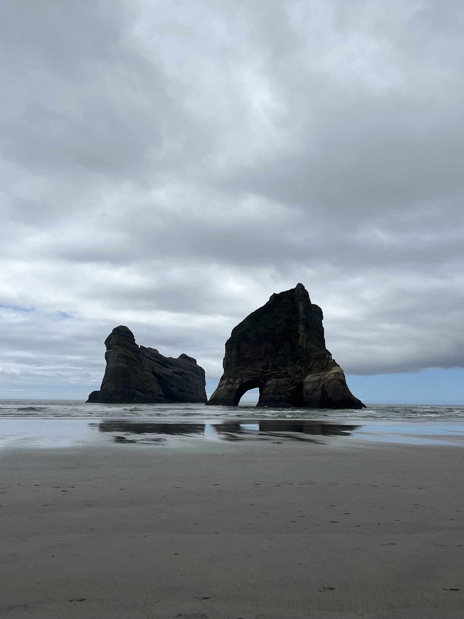
The walk is a straight forward amble from Wharariki beach car park through sheep pastures and coastal forest. Once you reach the beach, it is worth spending time wandering through the sand dunes, admiring the view and seeing if you can spot any seals! It is most well-known for its iconic offshore rock stacks that feature in a Windows 10 lock screen. It is also home to a seal colony where pups are often visible.


Beware – sadly, this beautiful beach was also the location of the biggest calamity of our trip. When we drove back from the beach the road was completely water-logged, flooding our engine which causing us to spend a night on the side of the track. Luckily the next day two kind men jump-started our engine and everything was okay, but be careful driving along this road after heavy rain!
Split Apple Rock, Abel Tasman National Park
Distance: 0.6km
Duration: 15 minutes
Elevation: 20 metres
Another lovely short walk in Abel Tasman! This one is even shorter, taking you on a gentle stroll through the forest and down to a beautiful golden-sand beach. The main attraction here is the unusual offshore spherical rock, which has split almost perfectly in two to create two separate halves.
The split rock is certainly impressive, but personally, I thought the beach itself was even more beautiful! We unfortunately visited on a rather gloomy day, so we didn’t get to see it at its best. However, I imagine on a sunny day it would be absolutely stunning.


It’s the perfect little walk if you’re looking for something easy and relaxing, and on a warm, sunny day, this would be a gorgeous spot for a swim!
Punakaiki Pancake Rocks and Blowholes
Distance: 1.1km
Duration: 15 minutes
Elevation: 5m
This is an easy paved loop track located in Paparoa National Park on New Zealand’s West Coast. During this walk you can explore the limestone formations that decorate this section of coast. There are phenomenal views of the beaches, lots of bird life and possibilities of seeing dolphins and other marine mammals here too.


These formations were formed 30 million years ago from compressed layers of dead marine creatures and plants on the seabed. Tectonic activity then lifted these beds, and over millennia, rain and seawater eroded the softer layers faster than the hard ones, creating these unique, stacked rocks we can see here today.


Devil’s Punchbowl Waterfall, Arthur’s Pass National Park
Distance: 2km
Duration: 45 minutes
Elevation: 150m


The start of this walk is located at the Punchbowl car park which is a 5 minute drive from Arthur’s Pass village. It is rather steep in places and has about 200 steps each way. There are also a few footbridges helping you over some river crossings. The walk takes you through beech forests with lots of bird life, before climbing in elevation until you reach the viewing platform at the base of the waterfall.


Devil’s Punchbowl is hugely impressive at 131m tall, and when the waterfall is flowing at full force, its spray envelops the platform and the sound is deafening.
Castle Rocks, Arthur’s Pass National Park
Distance: 1.4km
Duration: 20 minutes
Elevation: 10m
This is one of the more unique short walks in New Zealand and if you liked the sound of Punakaiki pancake rocks then this walk is also likely to intrigue you. It is an easy 20 minute walk to and from the rocks, but it is worth spending longer looking around. They are great to climb on and clamber over, and there’s loads of different shape rocks. It almost feels like a playground that has been carved from the earth itself!


This area was covered by a large inland sea hundreds of millions of years ago and sediment compression formed limestone rocks. The sea began to retreat about 30 million years ago and the pressure created the surrounding Torlesse and Craigieburn Ranges. After the sea retreated, limestone was left and water eroded it to create the rock formations you can see today. You can learn more about the history and importance to Māori people on information boards around the area.


Hokitika Gorge Walk
Distance: 2km
Duration: 30 minutes
Elevation: 30m
The Hokitika Gorge is a 30-minute drive from Hokitika town, with a large car park and toilets available when you arrive. From the car park, a short, easy walking track winds through lush native bush before reaching several viewpoints overlooking the spectacular turquoise water. This walk is absolutely stunning, the vivid blue of the water doesn’t look real even when looking at it with your own eyes!


Despite the Hokitika River often appearing calm, it can be dangerous in all weather and river conditions. Sudden drop-offs and strong currents make swimming unsafe, and sadly, people have drowned here, so swimming is strictly not advised.
Fun fact – The gorge’s striking blue-green colour is created by glaciers grinding down rocks, producing incredibly fine particles that remain suspended in the water. When sunlight hits these particles, it scatters the light and creates the vivid turquoise colour that the gorge is famous for.


The combination of the short, easy walk, lush forest and unbelievably blue water makes Hokitika Gorge one of the best short walks on New Zealand’s South Island.
Glenorchy Lagoon Scenic Walkway, Queenstown:
Distance: 4.9km
Duration: 1 hour 20 minutes
Elevation: 0m
I don’t whether this one should be classed as a ‘short walk’ really but is very easy walking, with no elevation at all! This is probably one of the prettiest walks I’ve ever done, with mountain view’s like no other.


Glenorchy is about an hour’s drive from Queenstown and is absolutely worth the journey. I parked at the waterfront car park and followed the trail from there. There are two options: a short 1.7km loop or a longer loop, which I chose, taking just under 5km from the car park and back.
The walk takes you across beautiful wetlands, with wooden boardwalks and little bridges along the way. It’s also a fantastic spot for birdlife, with plenty of black swans and smaller native birds, including fantails, flitting between the trees.


Honestly, the pictures speak for themselves with this one. If those views don’t persuade you to add this walk to your New Zealand itinerary, I don’t know what will!
Nugget Point Lighthouse, The Catlins
Distance: 1.8km
Duration: 25 minutes
Elevation: 93m
The walk to the lighthouse takes just under 15 minutes along a well-maintained, mostly easy path. The track was relatively busy when I visited, but there was plenty to see along the way, with abundant birdlife around the cliffs and the chance to spot fur seals and sea lions below.


Although I didn’t find the lighthouse itself particularly spectacular, the views from the lookout were absolutely incredible. From above, you can watch the sea lions swimming in the water and sunbathing on the rocks below.
And keep your eyes peeled, as you might get lucky with an even rarer sight! After someone pointed it out to me, I spotted a penguin sitting on the rocks, which we determined was a yellow-eyed (hoiho) penguin. Seeing one in the wild was such a special experience and definitely made this easy little walk even more memorable.


For other tips and tricks on where to find amazing wildlife in New Zealand, click here.
Kea Point, Aoraki/Mount Cook National Park
Distance: 3km
Duration: 41 minutes
Elevation: 89m
This is a gorgeous walk in the stunning Mount Cook National Park that is well worth doing. It leads to a viewing deck with panoramic views of Mueller Lake, Mount Sefton, and Aoraki/Mount Cook.


The walk is relatively easy, following a well-formed gravel path with sections of boardwalk and only gentle inclines. It’s a great option if you want to experience some of the incredible scenery around Mount Cook without committing to a long or strenuous hike.
Unfortunately, the weather wasn’t on my side when I did this walk, so I didn’t get to see the mountains in all their glory. However, even with the clouds, the scenery was beautiful, and I can only imagine how spectacular the views must be on a clear day!


Conical Hill Loop, Hanmer Springs:
Distance: 5.4km
Duration: 1 hour 30 minutes
Elevation: 190m
Again, this one is slightly longer for a ‘short walks’ post, but it is incredibly easy and the views are absolutely immense. The Conical Hill Loop Track starts right in Hanmer Springs and takes you through beautiful native forest before opening out at a wooden shelter with almost panoramic views across the surrounding mountain ranges.

Although there is some uphill walking, the well-maintained track makes it a straightforward and enjoyable walk, and the views at the top are more than worth the effort. It’s a great option if you want to get out into nature and experience some of Hanmer Springs’ spectacular scenery without taking on a challenging hike.


Thank you so much for taking the time to read this blog post. I hope it has inspired you to do at least a few of these shorter walks in beautiful New Zealand.
Please like this post, and comment if you have any questions at all.
Subscribe by typing in your email below.

Leave a Reply